Longley-Rice Model
The Longley-Rice (or irregular terrain) model predicts long-term median transmission loss over irregular terrain relative to free-space transmission loss.
The model was designed for frequencies between 20 MHz and 40 GHz and for path lengths between 1 km and 2000 km and was intended for frequency planning; mainly in television broadcasting1
- point-to-point mode
- area mode
The two modes are distinguished mostly by the amount of input data that is required. The point-to-point mode must provide terrain profile details of the link that the area prediction mode estimates using empirical medians.
Click and click the Computation tab.
Point-to-Point Mode
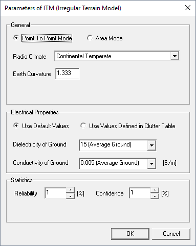
The point-to-point mode takes into account the terrain elevation profile between transmitter and receiver.

- General
-
- Radio Climate
- One out of seven predefined climate regions can be specified here.
- Earth Curvature
- This parameter will be used to determine the surface
refractivity.Note: Disable the Consideration of curvature of earth surface check box for simulations with this propagation model. Click and click the Pixel Databases tab.
- Electrical Properties
-
- Use Default Values
- A single value for dielectric permittivity and conductivity of the ground can be specified for the full simulation scenario. The drop-down boxes offer predefined values for typical environments. User defined values can be specified by selecting Arbitrary Value from the drop-down list and editing the field accordingly.
- Use Values Defined in Clutter Table
- In case the simulation project contains a clutter database, dielectric permittivity and conductivity parameters can be assigned automatically according to the specification of the clutter classes. This makes it possible to specify these parameters as location dependent.
- Statistics
-
- Reliability
- Level of reliability. Reliability refers to a measure of the variability that a radio system observes during its use.
- Confidence
- Level of confidence. Confidence refers to the variability that remains after specifying reliability, measurable in the aggregate of a large number of radio systems.
Area Mode
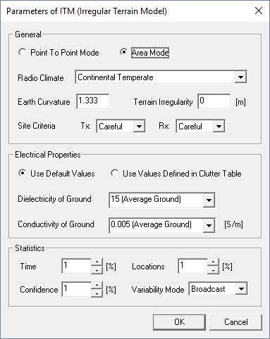
The area mode does not consider the terrain elevation database specified for the simulation project. The area prediction mode estimates the terrain profile using empirical medians. Therefore, some additional parameters have to be defined.

- General
-
- Radio Climate
- One out of seven predefined climate regions can be specified.
- Earth Curvature
- This parameter determines the surface refractivity.Note: Disable the Consideration of curvature of earth surface check box for simulations with this propagation model. Click and click the Pixel Databases tab.
- Terrain Irregularity
- This parameter describes the roughness of the terrain, which is defined as the inter decile value computed from the range of all terrain elevations for the area.
- Site Criteria
-
Criteria describing the care taken at each terminal to assure good propagation conditions. This is expressed qualitatively in three steps: random, careful, and very careful.
When the terminals of a system are usually sited on high ground and some effort is made to locate them at sites, where the signals appear to be particularly strong, the siting is very careful.
When most of the terminals are located at elevated sites, but with no attempts to select points where signals are strong, the siting is careful.
Finally, when the choice of antenna sites is dictated by factors other than radio reception, the siting is assumed to be random.
- Electrical Properties
-
- Use Default Values
- A single value for dielectric permittivity and conductivity of the ground can be specified for the full simulation scenario. The drop-down boxes offer predefined values for typical environments. User defined values can be specified by selecting Arbitrary Value from the drop-down list and editing the field accordingly.
- Use Values Defined in Clutter Table
- In case the simulation project contains a clutter database, dielectric permittivity and conductivity parameters can be assigned automatically according to the specification of the clutter classes. This makes it possible to specify these parameters as location dependent.
- Statistics
-
- Time
- Represents the fraction of time during which the losses are less than the calculated loss.
- Locations
- Represents the fraction of locations at which the losses are less than the calculated loss.
- Confidence
- Level of confidence. Confidence refers to the variability that remains after specifying reliability, measurable in the aggregate of a large number of radio systems.
- Variability Mode
- There are four different ways of handling the subject of variability:
- Single
- This mode combines all three types of variability. Typical use may be a single-use communication link, where confidence would be a measure of the combined variability, or it could be a mobile-to-mobile system, where the statistics would be reliability.
- Individual
- Time variability and combined situation/location variability. Typical user would be the individual receiver of a broadcast station for whom reliability means the time availability and confidence measures the combined situation/location variability.
- Mobile
- Situation variability and combined time / location variability. Typical user is a mobile system with a single base station. Reliability would refer to the combined time / location variability and confidence means the situation variability.
- Broadcast
- Time, location and situation variability are treated separately. Typical user would be the broadcaster for whom reliability would measure both location and time and confidence would measure situation variability.