Conversion of Topographical Data
Built-in converters in ProMan convert several file formats to the WinProp format. The supported file formats and selection of parameters are provided.
ProMan supports the following file formats:
- NPS/X data format (defined by Nokia)
- ASC data format (ASCII grid matrix)
- Binary grid format
- Wizard data format (defined by Agilent)
- MSI Planet data format (defined by MSI)
- MSI Tornada data format (defined by MSI and used by Siemens)
- Aircom Enterprise data format (defined by Aircom)
- Nokia NetAct data format (defined by Aircom and used by Nokia)
- Ericsson ASSET data format (defined by Aircom and used by Ericsson)
- USGS DEM
- USGS BIL
- HGT
- Digital terrain elevation data
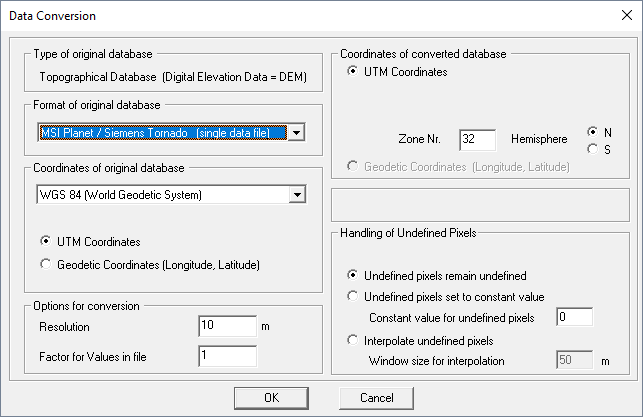
Step 1: Selection of Parameters
Databases can be converted by clicking .

There are several parameters available:
- Format of original database
- Select the format of the original database for the conversion.
- Coordinates of original database
- Select the coordinate datum of the original database. Depending on the type of format, this selection is not available, for example, HGT format only allows WGS 84 coordinates. Depending on the database format, you have to define the coordinates of the original database as well.
- Options for conversion
- Specify the resolution and the value by which the heights in the file can be scaled. This is useful if the source format is given in feet or inches. Additionally, depending on the file format, the resolution of the destination file can be defined.
- Coordinates of converted database
- Select the coordinates of the converted database (depending on the input format).
- Save database additionally in indoor database format
- Save the database to the indoor database format (.idb). This is useful if a detailed terrain profile is necessary for investigation of the radio channel with indoor wave propagation models (for example, ray tracing).
- Handling of undefined pixels
- Specify the handling of undefined pixels.
Step 2: Selection of Files and Conversion
After the parameters are defined, the files (source and destination) are selected, and the conversion is done. The topographic database is created in the .tdb file format. Depending on the topography, it can be split into several .tdb files.