WinProp is a complete suite of tools in the domain of wireless propagation and radio network planning. With applications
ranging from satellite to terrestrial, from rural via urban to indoor radio links, WinProp’s innovative wave propagation models combine accuracy with short computation time.
View the typical workflows when working with propagation simulations in specific scenarios, how to add a network planning
to a propagation simulation, include a receiver pattern, set up a time-variant scenario, include multiple-input multiple-output
(MIMO) at both the base station and the mobile station, connectivity analysis of sensor networks and optimization.
Use AMan to generate, edit and analyze a single antenna. Superimpose multiple antennas radiating similar signals to determine
the actual antenna pattern while taking into consideration the local environment.
Predict path loss between transmitter and receiver with ProMan. Perform network planning including the wireless standards (the air interfaces) and including multiple transmitters/receivers
(multiple base stations).
Additional channel characteristics like channel impulse responses, spatial channel impulse responses and angular profiles
can be displayed for user-defined locations in separate graphs.
The most important criterion to measure the performance of a prediction model is the accuracy. The accuracy of a prediction
models can be analyzed by comparing simulation results with measurements.
WinProp includes empirical and semi-empirical models (calibration with measurements possible), rigorous 3D ray-tracing models
as well as the unique dominant path model (DPM).
In WinProp various air interfaces and applications are pre-defined: broadcasting, cellular, wireless access, WiFi, sensor networks,
ICNIRP and EM compliance.
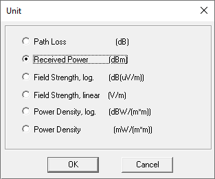
To change the unit of a result, click Edit > Convert Unit.
The following options are available on the Unit dialog:
Path loss (dB)
Received power (dBm)
Field strength, log. (dB(uV/m))
Field strength, linear (dBW/m2))
Power density (mW/ m2)
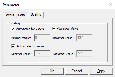
The unit for distance on a 2D value plot can be changed to nautical miles by clicking on
the plot and from the right-click context menu, click
Settings. On the Parameter dialog
(Scaling tab), select the Nautical
Miles check box.