Project Settings
Besides the topography also the land usage has an influence on the wave propagation. Therefore, land usage data (called either clutter data or morpho data) and building data can be used additionally to the topographical data with the prediction models. Clutter databases and building pixel databases can be used optional. They are not mandatory for the simulations / predictions.
Land usage data is based on different classes and the database defines the number of the class for the pixel at a given location. The assignment of class numbers to actual land usage is free and depends on the manufacturer of the database. Therefore ProMan offers the possibility to define a table with the assignment of class number and corresponding land usage properties.
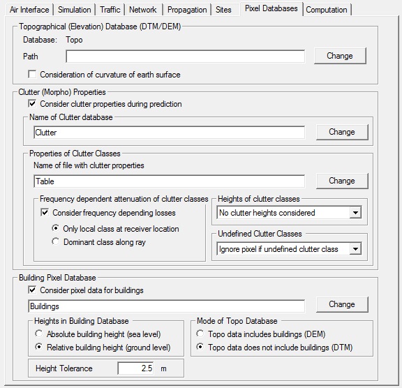
Settings

Figure 1. Settings on the Pixel Databases tab.
- Topographical (elevation) database (DTM/DEM)
- You can change the database file and its path. The database display is not
updated after a change of the database, therefore you should save the
project after a change of the database and open it again. Warning: If you change to a completely different database, your settings (for example, base station position) may not be valid any more.
- Consideration of curvature of earth surface
- The earth curvature can be considered during the simulations. This is
optional because it requires more memory and increases the computation times
significantly. For small areas (several kilometers) the influence is very
limited and therefore the earth curvature can be neglected. The earth radius
(6370 km) is multiplied with the correction factor. Depending on the
location on the earth (close to the equator or not) the correction factor
varies. For Europe, values of 4/3 = 1.33333 are typically
used.Note: Consideration of Earth curvature is not possible for satellite transmitters. If this option is enabled for satellite transmitters, ProMan automatically disables it during prediction To consider the Earth curvature anyway, satellite transmitters have to be defined as standard transmitters and have to be positioned well above the prediction area (the topography database).
- Clutter (morpho) properties
- Morphological properties of the area can be considered during the
prediction. For this purpose, an additional morphological database is
needed. This is optional and can therefore be disabled. The clutter database
does only contain a class ID for each pixel. The properties of the class are
defined in a clutter table. This clutter table must be additionally
specified when working with clutter databases.
- Properties of clutter classes
-
For each clutter class a frequency dependent attenuation can be defined in the clutter table. You can select if this additional attenuation is considered during the prediction or if the value is neglected. If no properties for a class ID are found in the clutter table, you can decide if the software should cancel all further prediction steps or if only this pixel is not predicted.
Most propagation tools only consider the class at the receiver pixel for the influence on the wave propagation. But this means, that if 90% of the distance between transmitter and receiver are, for example, in the clutter class urban and only the receiver pixel is in the class forest, the properties of the class forest would be used. This is obviously not correct if 90% of the area between transmitter and receiver are urban. Therefore, WinProp offers optionally the determination of the dominant class between transmitter and receiver and this class is then used for the evaluation of the receiver pixel. But some classes have a greater influence on the propagation than others. Therefore, each class can be assigned a weight factor. The higher the weight factor the stronger the influence of the class on the propagation.
Example: If 1 urban and 3 water classes are between transmitter and receiver and all classes would have the same weight (for example 1), the dominant class would be water. If the weight factor of urban would be 5 and the weight factor of water would be 1, the dominant class would be urban, because the total weight of urban would be 5 (1 class * 5 weights) compared to the total weight of water which would be 3 (3 classes * 1 weight).
- Building pixel database
- Building data in pixel format can be considered during the prediction additionally. The raster database containing the building data can be specified here. ProMan determines the shape and the height of the buildings depending on the values contained in the specified building pixel database (absolute or relative building heights) and the topographical database (digital terrain model without building heights or digital elevation model including building heights). The height tolerance value thereby defines the height difference between the values of the building pixel database and the topography data for which ProMan starts to detect buildings.