Defining Near Field Data from File
Import near field data from Feko field on a Cartesian boundary (.efe and / or .hfe), Sigrity input file (.nfd), MVG measurement file (.mfxml) or a CST near field scan (.nfs) to create a near field data definition. Use the near field data definition when defining an equivalent source or receiving antenna.
-
On the Construct tab, in the Define group, click the
 Field/Current Data icon. From the drop-down list
select
Field/Current Data icon. From the drop-down list
select  Import Near Field Data From File.
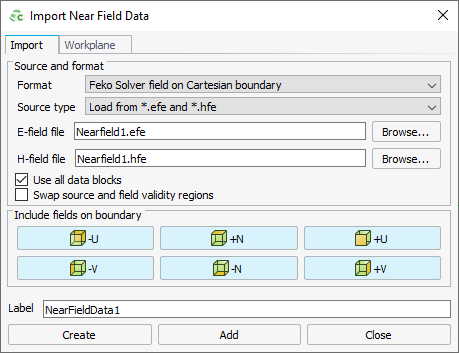
Figure 1. The Import Near Field Data dialog. -
To exclude a face (or faces) when importing Cartesian boundary near field data,
under Include fields on boundary, click the applicable
button(s) to disable the button and exclude the face.
 -U: Exclude the surface in the negative U
direction.
-U: Exclude the surface in the negative U
direction. +N: Exclude the surface in the positive N
direction.
+N: Exclude the surface in the positive N
direction. +U: Exclude the surface in the positive U
direction.
+U: Exclude the surface in the positive U
direction. -V: Exclude the surface in the negative V
direction.
-V: Exclude the surface in the negative V
direction. -N: Exclude the surface in the negative N
direction.
-N: Exclude the surface in the negative N
direction. +V: Exclude the surface in the positive V
direction.
+V: Exclude the surface in the positive V
direction.